The core of any slope stability analysis on the Milton landscape starts with a truck-mounted drill rig equipped with a hollow-stem auger boring into the Halton Till. This isn't just about drilling a hole; the rig's torque readings and the speed of penetration give us immediate feedback on the dense, silty clay matrix that defines the base of the Niagara Escarpment transition zone. We log the stratigraphy, extract Shelby tube samples from the critical failure plane depths, and prepare them for triaxial testing. The data feeds directly into our limit equilibrium models—whether we're using the Spencer or Morgenstern-Price method—to calculate a defensible factor of safety. For the softer, weathered shale near the surface in the Rattlesnake Point area, we pair these deep borings with a CPT test to capture a continuous profile of tip resistance, which helps identify thin, weak seams that a traditional split-spoon sample might miss entirely. Understanding the pore-water pressure regime via in-situ permeability testing is essential here, given the perched water tables that form after spring thaw.
Residual friction angles in Halton Till can drop to 18 degrees under fully softened conditions—your global factor of safety means nothing without accurate, site-specific lab data.
Service characteristics in Milton Ontario
Local geotechnical conditions in Milton Ontario
The contrast between the older, established neighborhoods near Mill Pond and the new subdivisions climbing the escarpment face west of Regional Road 25 is stark when it comes to slope stability risk. Around Mill Pond, the gradients are gentle—rarely exceeding 8 percent—and the thick till cover is relatively stable, with historical failure records limited to minor surficial sloughing during extreme rain events. Move to the upper bench near Kelso Conservation Area, and you're dealing with 30 to 45-degree slopes cut directly into fractured shale. Here, the risk isn't just rotational failure; it's wedge failure controlled by the orientation of near-vertical joint sets dipping 70 degrees to the southeast. We've mapped tension cracks opening 50 mm wide at the crest of several lots in the Beaty subdivision, a classic sign of incipient failure driven by freeze-thaw cycles and uncontrolled stormwater discharge from upslope development. Ignoring these signs isn't an option: a retrogressive failure in Queenston Shale can propagate 20 meters behind the crest in a single wet season.
Our services
Our approach to slope stability in Milton is built around a phased investigation that respects both the budget constraints of a small residential builder and the technical rigor demanded by a municipal infrastructure review. The following three service packages form the backbone of our escarpment practice.
Limit Equilibrium Modeling (SLOPE/W & Slide2)
Full 2D cross-section analysis using Spencer's method with rigorous inter-slice force convergence. We model multiple stratigraphic layers, piezometric surfaces from standpipe data, and apply NBCC 2020 seismic coefficients. Deliverables include a signed, sealed report suitable for site plan approval and conservation authority review.
Site Investigation for Slope Design
Program includes hollow-stem auger borings to a minimum depth of 2H below the toe, Shelby tube sampling at the failure plane, and piezometer installation. We log to the Unified Soil Classification System (USCS) and run consolidated-undrained triaxial tests at confining pressures matching the in-situ overburden.
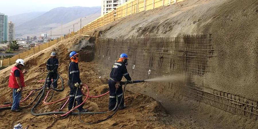
Remedial Design and Construction Oversight
From soil nailing and anchor design (CSA A23.3) to reinforced earth berms, we provide full-time field inspection during slope regrading. We verify that the as-built geometry matches the design profile within a 150 mm tolerance and that subdrainage systems function before backfill placement.
Frequently asked questions
How much does a slope stability analysis cost for a single-family lot in Milton?
For a typical residential lot on the Niagara Escarpment, a geotechnical investigation with slope stability analysis ranges from CA$1,720 to CA$6,000. The final cost depends on the number of boreholes, the depth to bedrock, and whether you need a simple infinite slope model or a full 2D limit equilibrium analysis. A straightforward lot with a 3-meter cut and good site access will fall at the lower end; a complex tiered lot requiring a drill rig with a 15-meter borehole, triaxial testing, and a signed engineering report for the conservation authority will approach the upper end.
What factor of safety is required for a permanent slope in the Town of Milton?
The Ontario Building Code, by reference to the CFEM and the local conservation authority guidelines, requires a minimum static factor of safety of 1.5 for permanent slopes and 1.3 for temporary construction cuts. For pseudo-static seismic conditions, a reduced factor of safety of 1.1 is generally accepted, provided the slope does not support a structure. We always run both short-term (undrained) and long-term (drained) analyses; in the Halton Till, the long-term drained condition typically governs.
Do you do the drilling yourself, or do you subcontract it?
We operate our own CME-45 truck-mounted drill rig with a hollow-stem auger and automatic SPT hammer, calibrated to ASTM D1586 energy standards. This means we control the drilling from start to finish—no waiting on a subcontractor's schedule, and no uncertainty about sample quality. Our driller has over a decade of experience in the shale and till of the Greater Toronto Area, and he can recognize a sheared clay seam in a split spoon sample as soon as it comes out of the hole.
What's the biggest mistake you see on slope failures in the Milton area?
Without question, it's ignoring the perched groundwater table. Builders assume the water table is deep in the bedrock and don't install proper subdrainage. Then a spring thaw or a 100-year storm saturates the upper 2 meters of fill, pore pressures spike, and the effective stress drops to zero at the critical failure plane. We've seen a 10-meter-high slope fail simply because a swale wasn't lined and the runoff infiltrated directly into a tension crack at the crest. The fix always costs ten times more than the prevention.