Skipping the geophysical survey on a Milton site often backfires. The town sits on a complex mix of Halton Till over Queenston shale, and assuming a default Site Class C on your NBCC submission can lead to a costly structural redesign when the building department pushes back. A standard borehole alone won't measure the low-strain stiffness the code demands. Our approach combines active-source MASW with triaxial geophone arrays to deliver a measured Vs30 profile, not an interpolated guess. For deeper stratigraphy where shale refusal is shallow, we often pair the surface wave data with a seismic refraction line to map the bedrock interface before the rig moves in, or run CPT soundings to correlate shear strength with the velocity model in the overburden.
A measured Vs30 from a 2D MASW line gives the structural engineer a defensible site class, not a conservative default that adds steel tonnage to the frame.
Service characteristics in Milton Ontario
Local geotechnical conditions in Milton Ontario
Milton’s development arc from a small mill town on the Credit River to a GTA commuter hub means older subdivisions coexist with new greenfield projects. The older inventory was built before modern seismic provisions, and infill projects on adjacent lots can encounter undocumented fill or buried creek channels with velocity inversions that a desk-based Vs30 assumption misses. The risk isn't theoretical: a soft layer trapped between stiffer till and shale can amplify ground motion at the structure's fundamental period. We've seen this in the Derry Road corridor where paleochannel deposits created a velocity contrast of 2:1 over a 50-meter distance. A targeted MASW line catches that anomaly before the footing design is locked, allowing the geotechnical engineer to adjust the bearing capacity or specify ground improvement like stone columns in the soft zone.
Our services
The MASW survey is part of a broader geophysical and geotechnical package. We configure the scope to your project phase, from preliminary site screening to final foundation design.
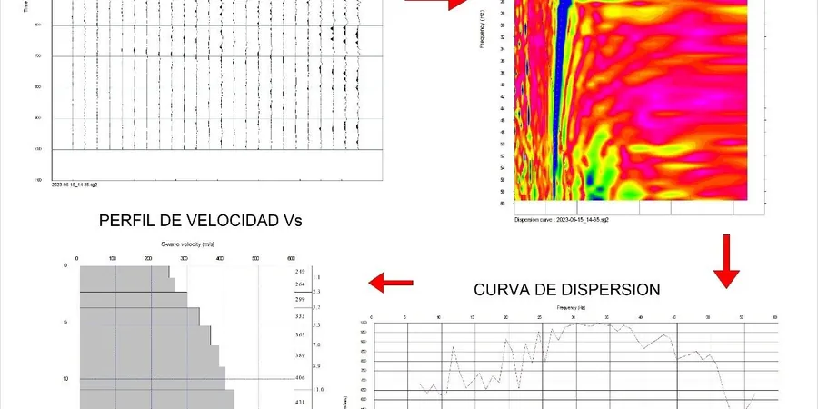
Vs30 Site Classification
Active MASW lines to determine the average shear wave velocity in the top 30 m per NBCC 2020. Output includes the site class letter and the Vs profile for the structural engineer's records.
2D Vs Cross-Sections
Multi-station MASW arrays processed with multi-mode inversion to map lateral velocity changes. Ideal for footprint-scale projects where soil variability is expected.
Downhole Seismic Correlation
Calibration of the surface wave model with a downhole tool in the same borehole, providing a direct travel-time measurement for quality assurance on critical structures.
Seismic Site Response Input
Layered Vs and damping ratio estimates prepared for 1D equivalent-linear site response analysis, compatible with programs like SHAKE or DEEPSOIL.
Frequently asked questions
Does the Town of Milton accept MASW for the NBCC site classification?
Yes. The building department accepts a measured Vs30 from an active MASW survey performed under ASTM D4428, provided the report is stamped by a licensed professional engineer in Ontario. We deliver the Vs profile, the dispersion curves, and the site class letter in a sealed report ready for permit submission.
What’s the typical cost for a MASW survey on a standard Milton lot?
A single-family residential lot survey with one or two MASW lines generally falls between CA$2,160 and CA$3,720. The exact figure depends on the array length, the number of shot points, and whether we need to correlate with a borehole or add a refraction line in areas with shallow shale.
How do you handle the shallow shale that’s common in Milton?
The Queenston shale can appear within 3 to 5 meters of the surface in northern Milton. Our inversion algorithm handles the high-velocity half-space properly, but we always cross-check with a seismic refraction line or a test pit to confirm the refusal depth. We do not extrapolate Vs30 from incomplete data.
Can you run the MASW test over asphalt or existing slabs?
We can, with a modified coupling setup using a base plate and higher-momentum source. The data quality is slightly lower in the upper 2 meters due to the stiff pavement layer, but the Vs30 value remains reliable because the bottom 28 meters dominate the time-averaged calculation. We flag the pavement effect in the report.